News

COMPASS data – project models, Story maps and more …

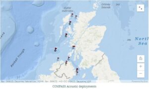
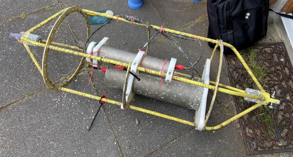
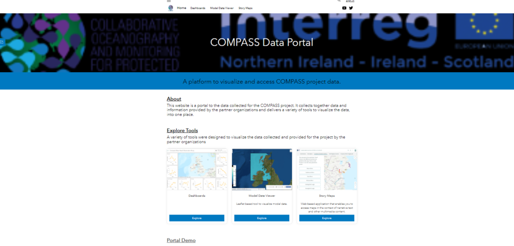
Unique among the three Interreg Va Marine Protected Areas projects, COMPASS has a dedicated work package on Data Management. One of the key goals of this work package was to provide a platform on the Web to allow general users to access the data collected from the network of monitoring buoys deployed by the partners. This builds on both technical and process knowledge shared between the project partners in the Data Management work package and combines data from the Oceanography, Salmonids and Modelling work packages in one location.

In addition to presenting the data in easy to access and understand forms (including graphs of observations and animations of model outputs), a story map has been developed with the Salmonids work package. Story Maps allow the combination of data (maps, graphs) with other media (text, videos, images) to improve the communication of narrative information about a dataset.


The web portal can be found here: https://compass-data-portal-marineinstitute.hub.arcgis.com/


The model visualisations can be found here: https://compass-data-portal-marineinstitute.hub.arcgis.com/pages/model-data-viewer


The Salmonids story map can be found here: https://storymaps.arcgis.com/stories/36821417d6b549d4a8f5639ad4181bbf

Marine Mammal deployments for COMPASS

Meet the COMPASS Scientists – Susanna Quer on the quest to understand marine mammals presence in North Altantic

The collection of underwater sound data within COMPASS continues into 2021. COMPASS researcher Susanna Quer, who has recently joined Marine Scotland Science and the COMPASS project as it embarks on its last year, has come back from the November survey on board Marine Research Vessel (MRV) Scotia, during which the COMPASS scientific moorings in the Minch and the Sea of Hebrides have been retrieved and redeployed. She explains the work undertaking and conditions experience during this research trip.

Susanna Quer on board Marine Research Vessel Scotia (November 2021)

“As the daily hours of light decrease, the wind gets colder and the conditions at sea become rougher, undertaking this work during November in the North Atlantic is not an easy task. It is only possible thanks to the immense help provided by the crew and the other scientists aboard this multi-disciplinary research survey. We sometimes refer to these surveys as “cruises”, but this is no cruise, in the vacation sense of the word! This survey is absolutely critical if we want to understand the presence of marine mammals in the area all year round, because the moorings retrieved in November have been listening to the sea since early summer, and the deployment of acoustic equipment during November record the sounds of the ocean and marine mammal presence close to the mooring throughout the winter season”.

“Winter is a time when other types of marine mammal surveys can be limited by daylight and weather. The ability of the devices to stay on for several months at a time allows us to record the sounds and noises of the sea for long periods and during hours of bad weather or darkness, rather than the “snapshots” during hours of daylight permitted by visual surveys. This is particularly relevant during the winter period, a season in which rough weather and short days do not allow scientists to conduct other types of surveys to understand marine mammal occurrence, such as land-based or boat-based visual surveys. Due to the weather, the sea state can make the observation of smaller species (e.g. harbour porpoise) particularly challenging”.

Stormy clouds during MRV Scotia research trip in North Atlantic, November 2021 (Credit: Susanna Quer)

COMPASS moorings are in fact one of the few monitoring programmes within the North East Atlantic to collect data throughout the whole year, which enables us to investigate seasonal patterns in the occurrence of whales and dolphins, helping paint a wider picture of the habitat preferences and distribution of species in the monitored area. Early data from the COMPASS project have shown increasing rates of occurrence during the winter season at four of the ten monitoring locations within the region: Tolsta Head, Stoer Head, the Shiant Isles and Stanton Bank. The data recovered by Susanna during this survey will allow us to expand our data set to cover the June-November period for a fourth consecutive year, the result of a huge effort on the part of the scientists and ship’s crew that lead this work.

For further detail on the location of receivers deployed through COMPASS go to the Marine Mammals (arcgis.com) Story map.

COMPASS 4th Annual Webinar held in November 2021

The focus of this year’s COMPASS Annual Webinar was IMPACT & LEGACY. The event was held on 2nd and 3rd November 2021 and a packed day of presentations and panel discussions was attended by a wide range of stakeholders. The topics covered reflected the achievements of the research teams across the project with a focus on oceanography, data management, model development and specific protected animals such as of cetaceans and salmonids. One of the key issues discussed at the event was the legacy of COMPASS and how it can encourage support and continuity for both the observational programmes and the outputs of the project. This will be continued a focus in the final year of this project, which completes in September 2022.

COMPASS Project

Meet the COMPASS Scientists – Jennifer Scott describes her work at the Loch Ewe Data Buoy

Jennifer Scott is an Oceanographer based at Marine Scotland and recently started working on the EU INTERREG funded COMPASS project. Here she explains her role on the project and the involvement of Marine Scotland on the project:

Jennifer Scott, Marine Scotland Science

I was fortunate to visit our monitoring site in Loch Ewe in late June to carry out maintenance on our pCO2 sensor and download the last few months of data. Having started at Marine Scotland Science as an Oceanographer on the COMPASS project in April of this year it was my first time meeting a colleague in real life and seeing them as more than just a face on a screen (thanks Pamela Walsham), and my first fieldwork for the project.

The pCO2 sensor we have deployed in Loch Ewe measures the carbon dioxide concentration of the surface water on a daily basis. With CO2 concentrations increasing in the atmosphere, and the oceans absorbing around a third of all of human emissions so far, we are monitoring the affects this is having on the chemistry of the water at Loch Ewe to better understand what this might mean for similar Scottish coastal environments.

Marine Scotland Science have been monitoring environmental conditions at Loch Ewe since 1999, with the initial measurements being surface water temperature. Since then we have upgraded to a shiny new data buoy which was deployed in December 2020. The data buoy is part of the COMPASS project’s network of monitoring buoys across the regional seas of the Republic of Ireland, Northern Ireland and West Scotland. It measures the surface water temperature and salinity, current speed and direction throughout the 40 m water column, wave height and direction, and weather conditions at the site every 10 minutes. We can then view the data live as the buoy is equipped to send the data out automatically.


Photo caption: The pCO2 sensor for Loch Ewe after the barnacles had been scraped off. Our maintenance checks involve removing anything trying to make the sensor its home and checking all of the electronics are in order. We then download the last 3 months of data and charge up the batteries before Jane Grant, our contractor at Loch Ewe who looks after the COMPASS pCO2 sensor and data buoy, returns the sensor to the water. (Photo credit: Jennifer Scott)

The data we are collecting in Loch Ewe from the data buoy and pCO2 sensor, along with weekly water sampling to measure physical water properties, nutrient concentrations and the plankton community for the Scottish Coastal Observatory, provide us with a detailed understanding of how our coastal waters vary through time. We need these long term monitoring programmes over multiple decades to identify long term changes in Scotland’s coastal ecosystems amongst the shorter term annual and seasonal variation.


Photo caption: The Loch Ewe COMPASS data buoy as seen from the Marine Scotland research vessel RV Scotia on a glorious sunny day in May 2021. The buoy is located in the outer basin of Loch Ewe, north west of the Isle of Ewe pictured here. (Photo credit: Helen Smith)

I am really looking forward to working further on the COMPASS project with the data coming from Loch Ewe. My role over the next year will involve creating a data management plan for the data buoy data to share this with the public, as well as assessing the scientific questions we can answer with the abundance of data we are collecting. Part of my time will also be spent visiting Loch Ewe, time I look forward to greatly!

For more information on the Loch Ewe site visit the dedicated Marine Scotland web page Loch Ewe COMPASS metocean buoy | Marine Scotland Information

COMPASS Digital Portal – NOW LIVE!

The Digital Portal for the COMPASS is live, go to COMPASS Data Portal (arcgis.com).

This portal collects together data from the project and information provided by the partner organisations and delivers a variety of tools to visualise the data, into one place.

The portal includes dashboards directly linked to the Network of Buoys, glider missions and Cefas waveriders. The portal also has a Model Data Viewer in which various oceanographic parameters can be selected over time/date series and depths. Story maps for the project can also be found on the portal with two available on data relating to Salmonid tracking and tagging and the second on location of acoustic receivers which have assisted in locating and understanding migration of whales and dolphins.

Acoustic receivers covered in barnacles recovered by COMPASS staff

Update on Network of Buoys

Servicing of the buoys

Due to the coastal locations of the COMPASS Network of Buoys they have to be able to withstand adverse conditions such as being battered by stormy weather and biofouling from algae and other sea life.  The equipment on each buoy needs to be robust, but to ensure accuracy and operation it still requires regular maintenance, calibration and repair.   The Mace Head buoy, located off Galway bay and operated by the Marine Institute, has endured 3 winters so far dealing with hurricane force winds from numerous Atlantic storms.  Similar to the other buoys instruments at Mace Head collect and transmit data on oceanographic and environmental conditions which are of interest to policy leads in managing Marine Protected Areas and understanding broader processes such as Ocean Acidification. 

The project is also deploying new moorings in other regions; the Agri-Food and Bioscience Institute, based in Northern Ireland, are upgrading the scientific equipment and telemetry systems at their 38a and Strangford buoys.  The new telemetry system installed at Strangford at the end of 2020 now means the project has near real-time transmission of data on conditions at the mouth of Strangford Lough, whilst the 38a mooring located in the Irish Sea is currently being completed with a package to be deployed during 2021.

Loch Ewe Buoy deployment

The Scottish Association for Marine Science is also in the process of replacing, maintaining and calibrating equipment on two of their moorings at Tiree and Firth of Lorne.  As with the other buoys, instruments are attached to a frame on each of the moorings and these require considerable logistics for the deployment and regular maintenance. 

Not only do the oceanographic teams have to replace and maintain instruments on the buoys, or repair mooring hardware, but in some cases the complete buoy has to be replaced which is the case with the buoy owned by Marine Scotland Science (MSS) at Loch Ewe.  The team at MSS have commissioned a second buoy to be deployed in the summer which will further support the Network and ensure a lasting legacy for the COMPASS project.

Data from Mace Head is live on Ditigal Ocean and available via the following link through the COMPASS project website Digital Ocean – COMPASS (compass-oceanscience.eu).  The project plans to add more buoy locations to Digital Ocean this year.