COMPASS
Collaborative Oceanography and Monitoring for Protected Areas and SpecieS
COMPASS Reports
Poster - Humpback Whale Song in the eastern N Atlantic
Poster contains findings from analysis of the Humpback Whale and what they can tell us about their migration and population numbers.
DownloadReport - Data Management Platform Requirements (Report 1)
In conjunction with other areas within the project the data management requirements for the COMPASS project have been defined at the start at the project. This ensures that as the project’s data management system is developed, both the needs of the data producers and the data users are catered for in the data management system. This report addresses the Platforms required for each task.
DownloadPoster - Monitoring small cetaceans using passive acoustics
This poster was produced for the World Marine Mammal Conference held in Barcelona (2019) on Monitoring small cetaceans using passive acoustics to inform cross cross-border conservation efforts
DownloadPoster - Cultivating a mutually beneficial ocean science data management relationship with brexit nations
This poster was presented by Andrew Conway at the Euro Geoscience Union 2020 virtual conference.
Download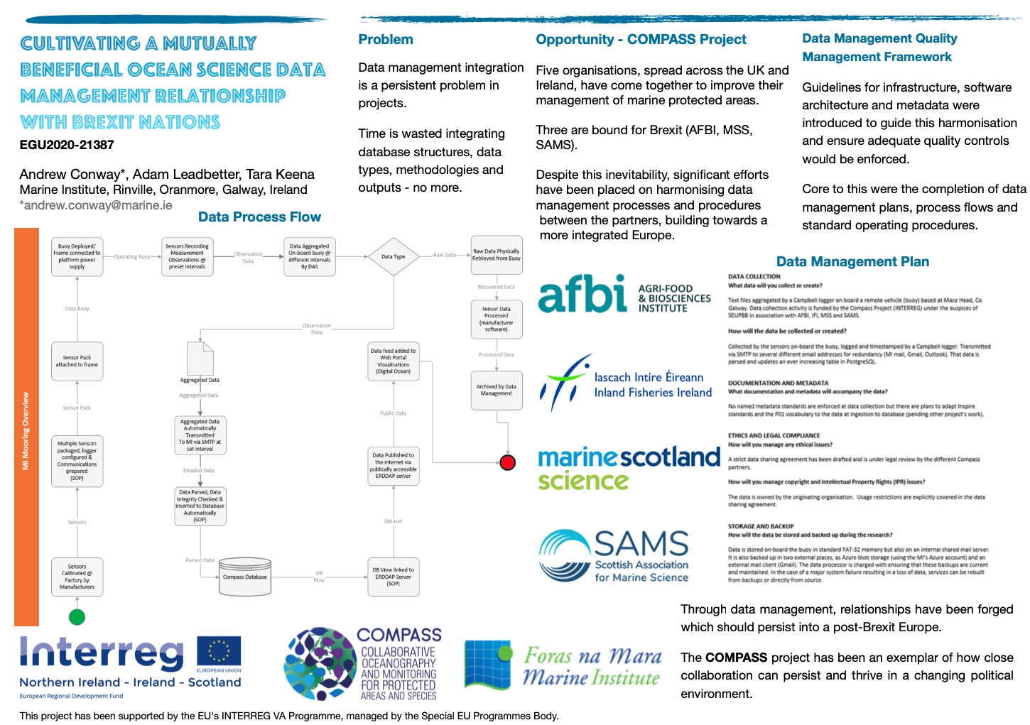
Fish migration Report
This document outlines preliminary findings and reports initial observations from salmon and sea trout detection data in the marine environment and provides examples of mapped fish tracks.
DownloadCurrent practices in data management
This report aims to report on the activity of a COMPASS Data Management workshop held in February 2018 jointly coordinated by European Marine Observation and Data network (EMODnet) and European Global Ocean Observing System (EuroGOOS).
DownloadCOMPASS Data Processes
The focus of this report therefore is to introduce the practices which the partners have for processing Compass data as well as describe the factors which have influenced the design of same. Some of the topics isussed herein can have specific dependencies and application outside of the scope of the Compass project, but where possible, the scope has been limited to the project only.
DownloadData Process Review Workshop Review
This report summarises the Data Process Review workshop held for the COMPASS project at the National Ocenography Centre, Liverpool, UK on 19th and February 2020. The workshop was a part of the project’s task on data management to document, review and revise data management processes at partner organisations and to promote data management best practices through a data management quality management framework approach based on ISO 9001 and accredited by the International Oceanographic Data and Information Exchange of UNESCO’s Intergovernmental Oceanographic Commission. The workshop was also an opportunity to share data management best practices and align data management processes with the related SeaMonitor and MarPAMM projects, also funded in the same Interreg scheme. Input to the workshop was also received from the British Oceanographic Data Centre (BODC) and the UK’s Marine Environmental Data and Information Network (MEDIN). BODC kindly hosted the event for the COMPASS project and the workshop was supported by MEDIN.
DownloadTechnical Report on model interfacing technology
This technical report is a detailed description/documentation of the two component models and of the methodology for interfacing them.
DownloadHindcasts of Hydrodynamic conditions
The COMPASS hydrodynamic hindcasts consist of 2016-2020 daily fields of different physical parameters relevant to the distribution of marine species that can be directly obtained from the hydrodynamic models used under the COMPASS project.
DownloadHabitat Layer Report
This report describes the format and contents of the data layers produced under the framework of the COMPASS project.
DownloadConnectivity Model
Methods were developed to enable marine connectivity calculations to be made using a combination of the best available model outputs covering the INTERREG VA region. This involved adaptation of particle tracking code to accept multiple hydrodynamic inputs and making automatic selection of relevant velocity information for particles within overlap areas. Pre-processing was developed in order to utilise output in multiple formats (FVCOM for the Scottish west coast, and ROMS for the larger Irish domain). Particle trajectories were recorded, in addition to “arrival” at suitable habitat sites, and post-processing carried out in order to estimate connectivity. A range of potential species were identified during workshops early in the project. As exemplars of the modelling approach, particles and habitats representing langoustine (Nephrops Norvegicus L.) and Horse mussels (Modiolus modiolus L.) are considered here.
DownloadData Flow Report
This report summarized the current status (at time of writing) of data flow from the Oceanographic elements of the COMPASS project. The COMPASS project seeks to establish an integrated network of Oceanographic buoys across the eligible area. This network of buoys consists of some existing moorings which are being enhanced to add additional parameters (such as pCO2, pH etc.) and some new moorings which are being established completely by COMPASS activity. As a result, there are oceanographic moorings that have a considerable amount of historical data and activity associated with them that may not have been supported by EU Interreg funding (such as Loch Ewe, Tiree and 38a), and there are other moorings (such as Mace Head) that are starting their data generation under the Interreg VA funding stream.
DownloadNew technology Report - oceanography
The Phase 1 report summarises new technology integration within COMPASS oceanographic platforms up to mid-2020. Activity to integrate and deploy new technology is ongoing, and specific sections of this report will be completed in Phase 2 when deployments are fully established.
DownloadData flow to Data management system (glider)
Within the T1 observational programme of COMPASS, glider missions in the summers of 2018 and 2019 have provided high-resolution datasets of water properties from the Malin shelf, spanning coastal Irish waters, coastal Scottish waters and Atlantic influenced waters near the shelf edge. Detailed here are the first two COMPASS glider missions, from 13/8/2018 to 19/10/2018 and from 6/8/2019 to 19/9/2019.
DownloadVulnerability of Marine Protected Areas to Climate Change
MarineSpace Ltd was commissioned by the Irish Marine Institute to conduct a review as a deliverable under the Interreg VA COMPASS project (Collaborative Oceanography for Marine Protected Areas and Species) to determine the current state of knowledge regarding the vulnerability of MPAs to climate change, with particular consideration of oceanic warming and ocean acidification.
DownloadUserguide for hindcasts
This document describes the hydrodynamic modelling component of the COMPASS project and provides a user guide to the hindcasts generated to simulate marine conditions across the INTERREG VA area during 2016-2020
DownloadBaleen Whale Report
This report aims to characterize the seasonal and diurnal patterns in two vocalizing baleen whale species in Scottish waters from the start of the COMPASS project to early 2019.
DownloadMarine Mammal Report (Harbour Porpoise Detections from CPOD data)
This report aims to characterize the seasonal and diurnal patterns in harbor porpoise occurrence, as detected from the first 31 months of monitoring as part of the INTERREG VA COMPASS project.
Download